| | Web Visualization > | | Chronicle article | Temporal Models | 2D Spacial Models | 3D Spacial Models | Parametric Models | Process Models |
Web Visualization for Teachers: 2D Spacial Models
Alistair B. Fraser
Comment: This document loads many objects. I have tried to
reduce download time by presenting low resolution versions.
But, some large objects may stream in slowly.
Scale
Often the problem is to communicate relationships between various spacial scales: e.g., the back yard, the town, the county the state the country the continent, the world. These are sometimes presented as a series of separate images, but of course in reality they are not separate, but different scales for the same thing. Computer visualization can make the mastery of this somewhat easier by offering a view of the spacial structure which allows zooming and panning. An example is presented on the right. It is a USGS image of the main campus of Penn State University taken on the morning of April 15, 1994. Use the control panel to zoom (or click in the picture once and then use the shift and control keys), and then grab the image and pan. As with the other objects in this document, this is a somewhat low resolution version of the resource.
 |
| Stitched cylindrical image |
Sometimes the objective is not as much to show the relationship between various scales as it is to show the relation between objects in various directions. The a panorama is very useful (I use the term panorama to cover any cases of a view covering an unusually large solid angle). Panoramas have been available for a very long time, but in the past they required equipment usually only available to the professional. Now with stitching software and processes such as QuickTimeVR for representation, they are easily within reach of anyone with an ordinary camera and some modest software. For some of the images shown here the only advantage the computer confers is in their creation, for others, there is also an advantage in the presentation (over that available, say, in a book).
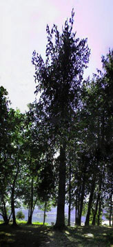
Tall picture: The image of the trees (right), taken from the front steps of my summer cottage in British Columbia, was created with a stitching program which combined
a series of individual moderately wide angle shots such as the thumbnail to the left. Although it looks as if it could have been taken as a single picture, I know of no commercially available lens which could have done it. Apart from the wide angle of view, there is the issue of the cylindrical projection (Mercator) which the stitching program offers as one of its mapping options. Most camera lenses have a rectilinear (tangent plane) projection, although some use an fisheye (equiangular) projection. The Mercator projection (beloved of geography teachers) is an option rarely available outside of stitching programs.

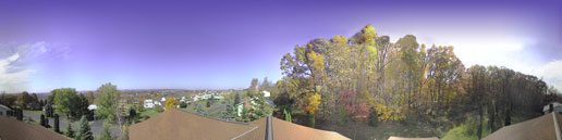 |
| Stitched image using a cylindrical (Mercator) projection covering 360 ° in azimuth Autumnal view from the roof of my (former) home in Lemont, PA. |
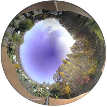 |
| Spherical projection of the same autumnal view. |
| Navigable QTVR panorama of my autumnal view, drag left or right (requires QuickTime) |
| | Web Visualization > | | Chronicle article | Temporal Models | 2D Spacial Models | 3D Spacial Models | Parametric Models | Process Models |